
With years of experience in GIS, RSI Softech Technology has honed its ability to deliver specialized solutions that address the unique needs of every client and industry.
Understanding industry requirements, we provide GIS maps and analytical data that cater to specific business needs, ensuring optimal results for various sectors.

From managing digital mapping data to delivering precise analytical knowledge, our GIS consulting services are designed to tackle complex geographic questions effectively.
From site analysis to spatial data management, the types of GIS Web & Mobile Applications available are diverse and can be tailored to meet the unique needs of various industries and applications.

Map concentrations, or an amount normalized by space or overall range, can be visualized by placing map components on a piece of paper in a way that takes real-world considerations into account.

An in-depth study employing GIS knowledge and other materials, together with customer consultation, are the first steps in our cartography and custom-making process. Then, before production and printing, we frequently move on to design, 3-D modeling, style, and knowledge overlays.
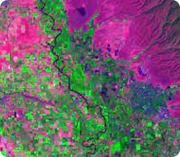
We work in sectors that offer services including satellite imagery for earth observation, natural resource boundaries, land use, and environmental monitoring. giving a clear, succinct, and accurate illustration of the course of events.

Applications for GIS might range from access to GIS tools to knowledge of GIS. We have experience developing ESRI-based mostly mobile applications and might supply development services across desktop, internet, and mobile platforms.

Incorporate high-resolution satellite imagery for detailed mapping and analysis. An in-depth study employing GIS knowledge and other materials, together with customer consultation, are the first steps in our cartography and custom-making process. Then, before production and printing, we frequently move on to design, 3-D modeling, style, and knowledge overlays.

In addition to GPS data and satellite photos, geospatial analytics also collects, processes, and visualizes knowledge from geographic information systems (GIS). For a lot of accurate modeling and trend predictions, they frequently develop spatial models and knowledge representations.

To establish the relative positions of points or other physical information for the gathering of spatial field data, RSI Softech offers the necessary data dimensions. For survey data collecting and mapping solutions, we employ the most recent technology and equipment.

RSI Softech is profound when it comes to the geospatial information production chain, with satellite images for earth observation, delimitation of natural resources, land use, and environmental monitoring. We pledge to provide services with the utmost accuracy.

GIS Telecommunication Mapping helps in mapping, modeling, and analyzing location-based datasets. It helps companies visualize your data, providing expertise in a highly specialized field.
GIS consultant manages digital mapping data and performs analysis of geographical statistics. GIS consultants make maps for clients, deduced from analytical data.
GIS Mapping, Data Digitization, Digital Photogrammetry, Remote Sensing, Data Conversion, Web & Mobile Application, Pole Loading Analysis, Cartography.
GIS technology paces with current trends, analyzing the acquired data and creating impact on the future of your business. With multiple maps in layers displaying datasets along with relevant information.
GIS integrates geographic intelligence into the planning process, increasing situational awareness by real-time data available to businesses. Assists in effective planning and also promotes better allocation of resources.