
At RSI Technologies, we combine LiDAR data with advanced processing techniques to create highly detailed and distortion-free orthophotos. These precise maps offer unmatched accuracy, enabling better visualization and analysis for geospatial projects.

Our Orthophoto Generation services cater to GIS professionals, surveyors, and geospatial enthusiasts alike. With visually stunning and data-accurate maps, we empower users to make informed decisions and plan with confidence across diverse applications.

By leveraging cutting-edge tools and expertise, RSI Technologies helps unlock deeper insights from geospatial data. Our orthophotos enable precision planning and analysis, transforming mapping projects and driving smarter outcomes.
From site analysis to spatial data management, the types of LiDAR Orthophoto Generation available are diverse and can be tailored to meet the unique needs of various industries and applications.
We employ cutting-edge technology to capture high-resolution aerial imagery. Our state-of-the-art equipment ensures that we collect the most detailed and up-to-date data for your project.
Our experts meticulously preprocess the raw aerial data, including geo referencing and rectification, to ensure that the images align precisely with the Earth's surface. This step eliminates any distortions caused by terrain or camera angles

The core of our service is the generation of orthophotos. We transform raw aerial imagery into accurate and distortion-free maps that can be used for various applications, from urban planning to agriculture.

We seamlessly stitch together multiple aerial images to create a single, continuous orthophoto mosaic. Our advanced software eliminates any visible seams, resulting in a smooth and cohesive map.

Beyond standard orthophotos, we offer additional enhancements such as color correction, contrast adjustments, and image sharpening to provide you with the highest-quality imagery.

Depending on your project's requirements, we can integrate elevation data, including digital elevation models (DEMs) and digital surface models (DSMs), to enrich your maps with terrain information.

We understand that different industries and businesses have unique needs. That's why we tailor our deliverables to suit your specific requirements. Whether you need geoTIFFs, GIS-ready files, or web-compatible formats, we've got you covered.

Our orthophotos seamlessly integrate with GIS mapping. This means you can easily overlay our maps with your existing geospatial data, enabling more in-depth analysis and decision-making
.png)
.png)
.png)
.png)
.png)
.png)
.png)

.png)
.png)
.png)
.png)
.png)
.png)
Being a well-known LIDAL company, RSI Softech Technology has a significant role in LIDAR classification. We offer customers all over the world specialized, professional LIDAR services. The list of services we offer includes aerial, mobile, and drone LiDAR, and it keeps growing as more industries, like forestry, transportation, flood mapping, and the environment, join our roster of clients.Our professional teams are capable to understand the requirements and process for new projects quickly. We ensure project deliver in time and faster with our stringent quality checking process. Get in touch with us via email.

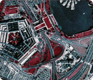
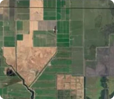
A Orthophotos are high-resolution aerial images that have been corrected for distortions caused by terrain variations and perspective. They provide accurate and visually clear representations of the Earth's surface, making them essential for various mapping and planning tasks.
A The integration of Orthophotos and LiDAR data with GIS and geospatial tools can enhance decision-making, improve accuracy, streamline resource management, and enable advanced spatial analysis. These benefits apply to industries such as agriculture, forestry, urban planning, and environmental conservation.
A We provide deliverables in various formats to suit your project's needs, including geoTIFFs, GIS-ready files (e.g., shapefiles), and web-compatible formats. Our goal is to ensure compatibility with your existing systems and software.
A We utilize state-of-the-art LIDAR sensors and equipment that ensure accurate and reliable data collection. Our technology is capable of capturing precise elevation and 3D information across various terrains.
A Yes, orthophotos can be used as a foundation for 3D modeling and visualization. When combined with elevation data, they can help create realistic 3D models of landscapes, buildings, and infrastructure.