
RSI Softech specializes in LiDAR and GIS services that revolutionize industries by shaping the future of mapping.

Our corridor mapping services focus on linear features like highways, railways, pipelines, and power transmission lines. With the integration of LiDAR, photogrammetric data, and cutting-edge AI software, we deliver precise and actionable insights.

Detailed corridor data supports infrastructure planning, maintenance, development, and environmental monitoring, helping our clients achieve sustainable growth.
From site analysis to spatial data management, the types of LiDAR Data Processing services available are diverse and can be tailored to meet the unique needs of various industries and applications.

Railway corridor mapping is vital for efficient track planning, maintenance, and passenger safety. Our services provide detailed data for designing tracks, monitoring conditions, identifying hazards, and ensuring reliable operations.
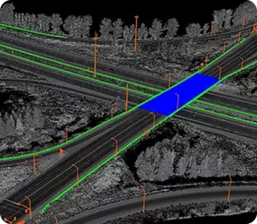
Road corridor mapping supports infrastructure planning, design, and maintenance. Our services aid traffic management by analyzing patterns, optimizing signals, and enhancing road safety.

Oil and gas mapping provides vital geological data to identify drilling sites, estimate reserves, and support resource allocation, driving efficient exploration and production.

Our utility mapping prevents damage to underground utilities and supports environmental assessments. Powerline inspections ensure grid safety, reduce risks, and prevent outages.

Our power line inspection services ensure the safety and reliability of electrical grids by identifying potential issues early. Regular inspections help prevent outages, reduce risks, and maintain efficient power distribution.
.png)
.png)
.png)
.png)
.png)
.png)
.png)

.png)
.png)
.png)
.png)
.png)
.png)
Being a well-known LIDAL company, RSI Softech Technology has a significant role in LIDAR classification. We offer customers all over the world specialized, professional LIDAR services. The list of services we offer includes aerial, mobile, and drone LiDAR, and it keeps growing as more industries, like forestry, transportation, flood mapping, and the environment, join our roster of clients.Our professional teams are capable to understand the requirements and process for new projects quickly. We ensure project deliver in time and faster with our stringent quality checking process. Get in touch with us via email.

A LIDAR Corridor Classification is used in transportation planning, urban development, environmental monitoring, power line inspection, and disaster management, among other applications.
A LIDAR helps in studying vegetation growth, and riverbanks, and assessing flood risk, contributing to better environmental management and conservation.
A LIDAR provides highly accurate 3D data compared to traditional mapping methods, making it especially useful for corridor classification where precision matters.
A Yes, LiDAR can be used both indoors and outdoors, making it versatile for various applications, including building interior classification.
A Yes, LIDAR data can be processed and integrated with GIS, allowing for spatial analysis, modeling, and decision-making in a geospatial context.